Researchers: T. Telbisz, L. Mari, B. Székely, J. Móga and many others…
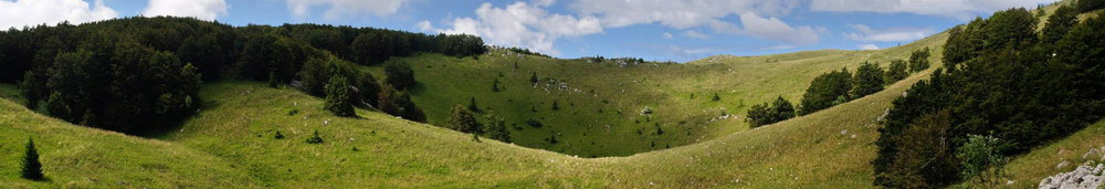
Aim: Measurement of shape parameters and spatial pattern of dolines. As dolines are "diagnostic karst features" (Ford, Williams), the study of dolines helps us to understand karst processes
3D Models: of dolines - HERE
Research questions:
- How large, how deep, how much elongated are dolines of a given study area in statistical terms?
- How densely is the terrain covered by dolines?
- Why are they so large? Or so small?
- What are the best parameters to describe doline sizes?
- How strong are correlations between different doline parameters?
- What is the relationship of lithology, tectonics, topography, climate, time, stream network and doline parameters?
- What is the main control of doline density?
- Can the genesis of dolines be better understood by morphometry?
Study areas:
- Aggtelek Karst, Bükk Mts (Hungary)
- Slovak Karst (Slovakia)
- Trascău Mountains, Pădurea Craiului, Codru-Moma in Apuseni Mts (Romania)
- Biokovo Mt (Croatia)
- Miroć Mt (Serbia)
- Canin Mt (Italy/Slovenia)
- Sinjajevina Mt (Montenegro)
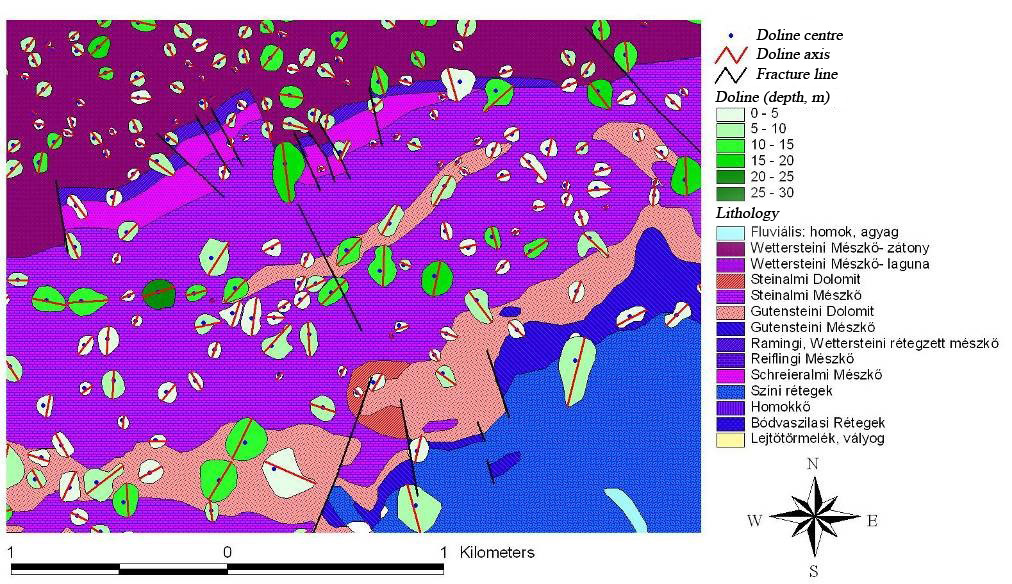
Methods: Previously, contour maps were the main data source. Nowadays, LiDAR and SfM data are used. GIS is used as a general framework, and DTMs are the most important base data. Of course lithologic maps and field GPS measurements are also applied.
Map: Online map of Hungarian karst terrains. See HERE.
Some results:
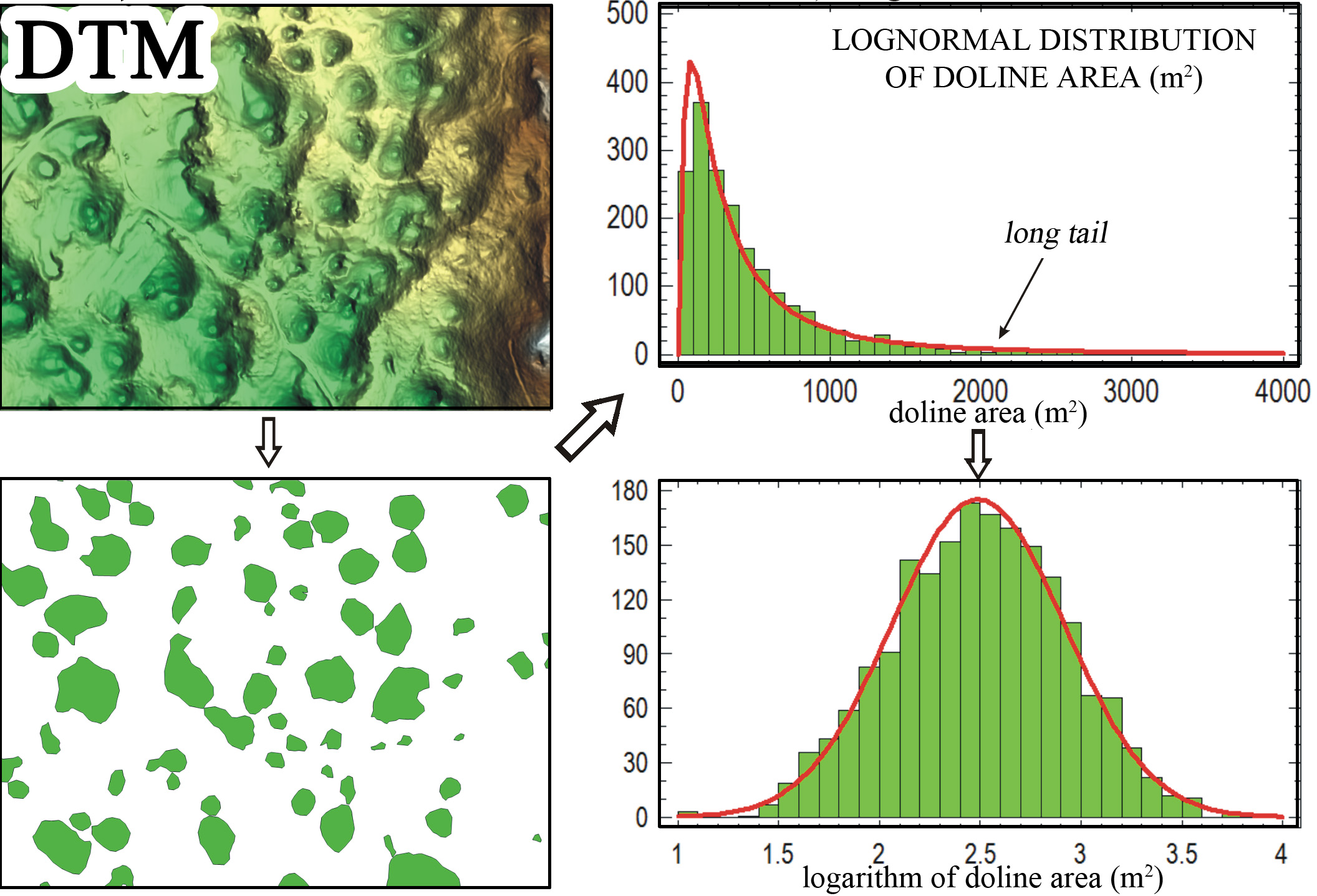
- Doline area is a good and robust indicator of doline size and generally, it is in good correlation with length, perimeter. But not with depth! Depth is also correlated with area, but only moderately – it means that depth is an „independent” indicator and depth-width ratio should be an important parameter in all doline morphometrical studies!
- Distribution of doline area follows a lognormal distribution. Or a power-law distribution? This question is still partly open… In fact, for most part of the population these distributions are very similar. What is the meaning of „lognormal”? Theoretically, it means that the logarithm of the original value (here: area) follows a normal distribution. Practically, it means that you have many small dolines and only few large dolines, but occasionally extreme-size (i.e. 100 times larger then the „typical”) dolines can also occur. Many other natural phenomena are similar…
- Doline density is only fairly controlled by lithology. Of course, you need a well-karstifiable rock for the formation of dolines. But, if you have, the density is controlled by many other factors, e.g. TIME, the connection with fluvial terrains, etc.
- The formation and evolution of dolines is strongly controlled by tectonic fractures. The main axis is usually oriented along the main fault lines. But the nearest neighbour directions are rather parallel with secondary fractures.
- Topographic controls on doline formation can be also quantified. Most dolines are formed on terrains whose mean slope is less than 12°.
- For further details, see the publications...
Selected publications:
in English
Pardo-Igúzquiza, E., Dowd, P. A., & Telbisz, T. (2020). On the size-distribution of solution dolines in carbonate karst: Lognormal or power model?. Geomorphology, 351, 106972. LINK
Telbisz, T., Látos, T., Deák, M., Székely, B., Koma, Z., & Standovár, T. (2016). The advantage of lidar digital terrain models in doline morphometry compared to topographic map based datasets–Aggtelek karst (Hungary) as an example. Acta Carsologica, 45(1), 5-18. PDF
Székely, B ; Telbisz, T ; Koma, Zs ; Kelemen, K ; Szmorad, F ; Deák, M ; Látos, T ; Standovár, T (2015). Geomorphometric correlations of vegetation cover properties and topographic karst features based on high-resolution LiDAR DTM of Aggtelek Karst, NE Hungary. Geophysical Research Abstracts 17 Paper: EGU2015-12888. PDF
Telbisz, T., Eisam Eldeen, F., Imecs, Z., & Mari, L. (2014). Geomorphometric Analysis And The Evolution Of Drainage Network In Trascău Mountains (Romania). Carpathian Journal of Earth and Environmental Sciences, 9(4), 5-17. PDF
Telbisz, T. (2010): Morphology and GIS-Analysis of closed depressions in Sinjajevina Mts (Montenegro). Karst Development, 1, 1, 41-47. PDF
Telbisz, T. (2010): Glacio-karst features of the Sinjajevina Mts (Montenegro): an overview and DEM analysis. Karst Development, 1, 2, 17-22. PDF
Telbisz, T., Mari, L., & Szabó, L. (2011). Geomorphological characteristics of the Italian side of Canin Massif (Julian Alps) using digital terrain analysis and field observations. Acta Carsologica, 40(2).255-266. PDF
Telbisz, T ; Dragušica, H ; Nagy, B. (2009): Doline Morphometric Analysis and Karst Morphology of Biokovo Mt (Croatia) based on Field Observations and Digital Terrain Analysis. Hrvatski Geografski Glasnik/Croatian Geographical Bulletin 71, 2, 2-22. PDF
in Hungarian with English abstract
Telbisz, T., Boer, Á., Csernátoni, A., Imecs, Z., Mari, L., Bottlik, Z., & Szabó, O. (2015). A Királyerdő karsztvidéke: morfológiai kérdések és élet a karszton. Karst Development/Karsztfejlődés, 20, 167-184. PDF
Telbisz, T ; Ádám, E. (2011): A Felső-hegy, a Mészkő-tető, a Barkai- és a Szádelői-fennsík domborzati és töbör-morfometriai elemzése térinformatikai eszközökkel. Karsztfejlődés, 16, 87-102. PDF
Telbisz, T ; Móga, J. ; Kósik, Sz. (2009): A Pelsőci-fennsík digitális domborzatelemzése és töbör-morfometriai jellemzése. Karsztfejlődés, 14, 121-138. PDF
Telbisz, T ; Mari, L ; Kohán, B ; Čalič, J. (2007): A szerbiai Miroč-hegység töbreinek térinformatikai és GPS-es terepi vizsgálata. Karsztfejlődés 12 pp. 71-90. PDF
Telbisz, T ; Móga, J ; Kósik, Sz. (2006): Töbör-morfometriai elemzések a Szilicei-fennsík délnyugati részén. Karsztfejlődés, 11, 133-152. PDF
Telbisz T., Mari L., Kohán B. (2006): A Karas-szurdok (Aninai-hegység) környékének digitális domborzatelemzése és a helyszínen végzett GPS-es töbör-felmérések tanulságai. Karsztfejlődés, 11, 117-131. PDF
Telbisz, T ; Móga, J. (2005): Töbör-morfometriai elemzések a Szilicei-fennsík középső részén. Karsztfejlődés, 10, 245-266. PDF
Telbisz, T. (2003): Töbörfejlődési szimuláció elemzése lepusztulási idősorok és morfometriai mutatók alapján. Karsztfejlődés,8 51-79. PDF
Telbisz, T. (2001): Töbrös felszínfejlődés számítógépes modellezése. Karsztfejlődés, 6, 27-43. PDF
Telbisz, T. (2001): Új megközelítések a töbör-morfológiában az Aggteleki-karszt példáján. Földrajzi Közlemények, 125(1-2), 95-108. PDF